

The arrival of Mauritius Street View is set to change how tourists plan their island adventures. For years, visitors could only trace lines on a map, unable to see the roadside palms waving outside their future hotel or the path down to their next swim spot. That all changes starting this July, as Mauritius gets mapped in interactive, 360-degree glory for Google Maps and Google Earth.
Key details: Mauritius Street View project
- Project dates: July 19 to August 21, 2026
- Coverage: Entire island, including public roads, tourist sites, and historic monuments
- Operator: World Travel in 360 (WTI 360 Ltd), with support from Mauritius Tourism Promotion Authority (MTPA)
- Google’s privacy standards: All faces and vehicle license plates automatically blurred before images go live
Why Mauritius Street View matters for tourists
Mauritius has always been a dream destination, but it was a digital blind spot on Google Street View. While most of the globe’s top travel spots let you explore streets and sights online, Mauritius lagged behind, meaning planning your route from the terminal to your hotel, or checking if your guesthouse is really beachfront, depended on guesswork or old photos. If you’re someone who likes to see exactly where you’re going before you get there, this is big news.
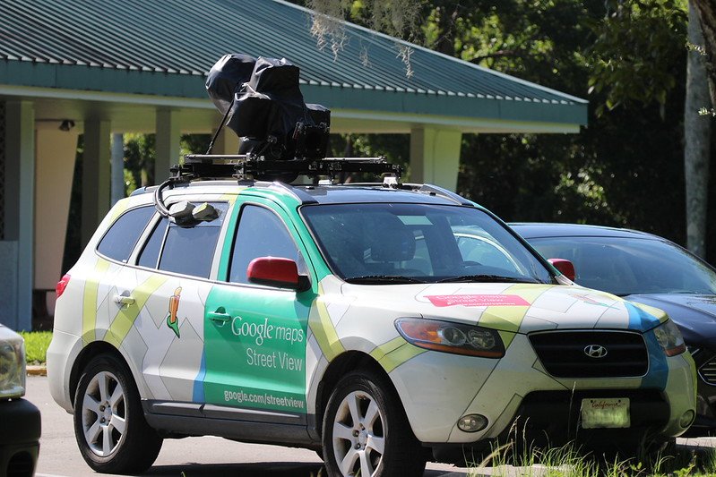
Between July 19 and August 21, you might spot four camera-topped vehicles cruising the coastal roads or weaving through Port Louis traffic. They’ll be capturing ultra-high definition images, revealing every corner from hidden alleyways to popular attractions. Once processed, these images will appear on Google Maps and Google Earth for anyone to explore, wherever they are in the world.
Mauritius Trip Planner
What does this mean for travel planning?
- Preview your surroundings: Check if your hotel has a quiet street or sits near a night market. Figure out how walkable those gorgeous beaches actually are from where you’re staying.
- Better navigation: Avoid surprises with tricky intersections or one-way streets, especially handy for first-time visitors renting cars.
- Plan days out: Virtually tour attractions, markets, and public transport routes before you fly, ideal for families, adventurers, and accessibility needs.
If you’re a detail-oriented planner or want reassurance before booking, Street View brings clarity. And for anyone returning to Mauritius after years away, it’s a fun way to see what’s changed before you arrive.
How digital mapping benefits everyone
The benefits of Mauritius Street View stretch beyond tourists. Hotels and restaurants become easier to find on Google, and their surroundings more transparent to guests. In the long run, this could reshape how local businesses promote themselves, and how quickly travelers can trust what they see online.
For locals, it means better tools for route planning, community navigation, and yes, fewer missed turns on the way to family gatherings. On a broader scale, visual records like these are also valuable for urban planning, keeping track of rapid changes, and helping authorities respond to emergencies, every road, monument, and public square will have a time-stamped, archived image.
Some practical advice from an island local
As someone who drives around the island almost daily, I see a lot of first-timers struggling with street names (some barely marked), tight parking, and unexpected detours. Street View will definitely help you get a feel for the real landscape, a huge advantage when you’re finding that little guesthouse down a coastal lane or plotting the day’s stops. And while it’s winter here, July and August are still ideal for exploring outdoors, whether you’re going from Grand Baie to Le Morne or looking for the best roti truck near Flic en Flac.
If you see one of those camera cars out there, give them a wave. You might end up, safely blurred, on Google Maps before your next visit.
Source: ilemauricetourisme.info
Frequently Asked Questions
When is Mauritius Street View being captured?
The imaging project takes place from July 19 to August 21, 2026, with camera cars traveling Mauritius’s roads.
Which areas will be included in Mauritius Street View?
The coverage will include all public roads, major attractions, and historic sites across the island.
How is privacy protected in the Street View images?
Google’s technology will automatically blur all faces and vehicle license plates before the images go live.
Curious to see Mauritius like a local? Explore real neighborhoods and attractions with expertly guided tours from MauritiusEvents.com.
Explore island sightseeing tours →